
The Arecibo Legacy Fast ALFA Survey
ALFALFA Sky Coverage
ALFALFA was originially intended to cover 7074 square degrees of the high
galactic latitude sky
accessible to the Arecibo telescope, i.e. the regions between 0°
and +36° in Declination (subdivided into 9 bands of tiles, each
4° wide), 07h30m to 16h30m and
22h to 03h in Right Ascension. In the end, some parts of
the spring sky were observed only from 08h30m to
15h30m so that the final coverage is only of
about 6300 square degrees.
The survey was conducted in drift mode, following a 2--pass strategy
(i.e. each Declination band was scanned at two different epochs,
separated by a few months) with the ALFA system. The total allocation,
including overhead was 4,741.5 hours allocated in 808 separate
observing periods between 5 Feb 2005 and 26 Oct 2013.
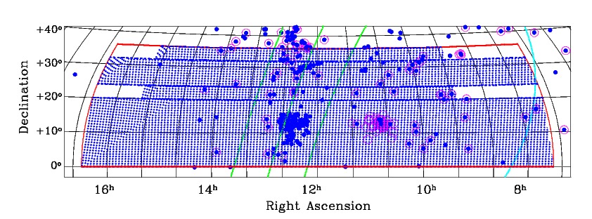
 Final sky coverage of the ALFALFA survey, in the Virgo (upper) and
anti-Virgo (lower) directions. In each panel, the solid red
lines outline the proposed survey area. The Arecibo telescope
is located at a latitude of 18°21' N and can survey
zenith angles less than 20°, but the sensitivity drops
sharply at Z.A. > 18°. The dotted red lines
make the designated ALFALFA "tile" boundaries while the blue
hatched areas reflect the actual final sky coverage.
The cyan lines mark
the lines of b = +20° (upper) and -20° (lower)
while the green lines trace SGL = -10°,
0° and +10°.
Blue filled circles mark galaxies with observed heliocentric
recessional velocities cz < 700 km/s while
open magenta circles denote objects believed to lie with 10 Mpc
(Karachentsev et al. 2004), based largely on primary distances.
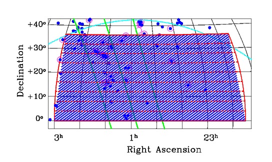
Final sky coverage of the ALFALFA survey, in the Virgo (upper) and
anti-Virgo (lower) directions. In each panel, the solid red
lines outline the proposed survey area. The Arecibo telescope
is located at a latitude of 18°21' N and can survey
zenith angles less than 20°, but the sensitivity drops
sharply at Z.A. > 18°. The dotted red lines
make the designated ALFALFA "tile" boundaries while the blue
hatched areas reflect the actual final sky coverage.
The cyan lines mark
the lines of b = +20° (upper) and -20° (lower)
while the green lines trace SGL = -10°,
0° and +10°.
Blue filled circles mark galaxies with observed heliocentric
recessional velocities cz < 700 km/s while
open magenta circles denote objects believed to lie with 10 Mpc
(Karachentsev et al. 2004), based largely on primary distances.
Figure by mph (01/05).
Last modified: Sun Feb 17 13:53:54 EST 2013 by martha